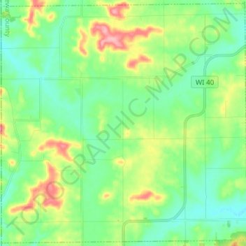
点击地图以显示海拔。
名称:Town of Cooks Valley地形图、海拔、地势。
地点:Town of Cooks Valley, Chippewa County, Wisconsin, United States (45.02995 -91.65151 45.11424 -91.52898)
平均海拔:332 米
最低海拔:297 米
最高海拔:412 米
点击地图以查看其地形、其海拔和其地势。
United States > Wisconsin > Chippewa County > Town of Lafayette
平均海拔:285 米
United States > Wisconsin > Chippewa County > Chippewa Falls
平均海拔:277 米
平均海拔:279 米
United States > Wisconsin > Chippewa County
平均海拔:325 米