
Adelaide地形图
点击地图以显示海拔。
Adelaide
Adelaide is north of the Fleurieu Peninsula, on the Adelaide Plains between the Gulf St Vincent and the low-lying Mount Lofty Ranges. The city stretches 20 km (12 mi) from the coast to the foothills, and 90 km (56 mi) from Gawler at its northern extent to Sellicks Beach in the south. According to the Regional Development Australia, an Australian government planning initiative, the "Adelaide Metropolitan Region" has a total land area of 870 km2 (340 sq mi), while a more expansive definition by the Australian Bureau of Statistics defines a "Greater Adelaide" statistical area totalling 3,259.8 km2 (1,258.6 sq mi). The city sits at an average elevation of 50 metres (160 ft) above sea level. Mount Lofty, east of the Adelaide metropolitan region in the Adelaide Hills at an elevation of 727 metres (2,385 ft), is the tallest point of the city and in the state south of Burra.
关于这张地图
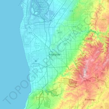
名称:Adelaide地形图、海拔、地势。
平均海拔:148 米
最低海拔:-1 米
最高海拔:709 米
其他地形图
点击地图以查看其地形、其海拔和其地势。