
Atco地形图
点击地图以显示海拔。
关于这张地图
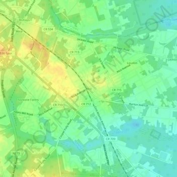
名称:Atco地形图、海拔、地势。
平均海拔:43 米
最低海拔:30 米
最高海拔:57 米
其他地形图
点击地图以查看其地形、其海拔和其地势。
Haddon Heights
United States > New Jersey > Camden County
In 1890, Benjamin A. Lippincott constructed a passenger station in the center of his land for the Atlantic City Railroad. Then Lippincott, with Charles Hillman, filed a grid street plan with Camden County to develop a community. They named it Haddon Heights because of its proximity to Haddonfield and its high…
平均海拔:20 米
Cranford Road Park
United States > New Jersey > Camden County > Cherry Hill Township > Woodcrest
平均海拔:25 米