
Pithapuram地形图
点击地图以显示海拔。
Pithapuram
Pitapuram is located at 17°07′00″N 82°16′00″E / 17.1167°N 82.2667°E / 17.1167; 82.2667. It has an average elevation of 10 meters (33 feet). The town is approximately 20 kilometres from the district headquarters, Kakinada, and 75 kilometres from Rajahmundry. In 1957, Pitapuram was designated as a 2nd grade Municipality and an urban local body (ULB). It is spread over an area of 19.57 square kilometres.
关于这张地图
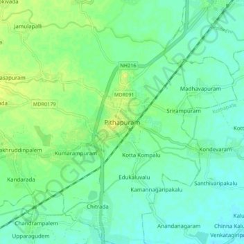
名称:Pithapuram地形图、海拔、地势。
地点:Pithapuram, Kakinada, Andhra Pradesh, 533450, India (17.07334 82.21433 17.15334 82.29433)
平均海拔:13 米
最低海拔:6 米
最高海拔:24 米