
West New Boston地形图
点击地图以显示海拔。
关于这张地图
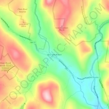
名称:West New Boston地形图、海拔、地势。
平均海拔:356 米
最低海拔:237 米
最高海拔:488 米
其他地形图
点击地图以查看其地形、其海拔和其地势。
Pittsfield
United States > Massachusetts > Berkshire County
Pittsfield has a humid continental climate (Dfb). Winters are harsh due the city's high elevation at 1,039 ft (317 m), with an average annual snowfall of 75.9 inches (1,930 mm) and temperatures dipping to 0 °F (−18 °C) or colder 13 times per year. Summers, however, are typically warm and pleasant, with…
平均海拔:369 米
Adams
United States > Massachusetts > Berkshire County
According to the United States Census Bureau, the town has a total area of 23.0 square miles (59.5 km2), of which 22.9 square miles (59.3 km2) is land and 0.077 square miles (0.2 km2), or 0.33%, is water. The town lies along the valley surrounding the Hoosic River and its tributary brooks. Set between the…
平均海拔:481 米
Pittsfield
United States > Massachusetts > Berkshire County
Pittsfield has a humid continental climate (Dfb). Winters are harsh due the city's high elevation at 1,039 ft (317 m), with an average annual snowfall of 73.0 inches (1,850 mm) and temperatures dipping to 0 °F (−18 °C) or colder 13 times per year. Summers, however, are typically warm and pleasant, with…
平均海拔:369 米
Pittsfield
United States > Massachusetts > Berkshire County
Pittsfield has a humid continental climate (Dfb). Winters are harsh due the city's high elevation at 1,039 ft (317 m), with an average annual snowfall of 75.9 inches (1,930 mm) and temperatures dipping to 0 °F (−18 °C) or colder 13 times per year. Summers, however, are typically warm and pleasant, with…
平均海拔:369 米
Peru
United States > Massachusetts > Berkshire County
Peru has the highest mean altitude in Massachusetts and, along with neighboring Windsor, is one of only two municipalities in the state with a mean elevation above 2,000 feet. It lies on high ground in the Berkshire Hills, with three main peaks in the town. Much of Peru is forested, with a large portion of the…
平均海拔:528 米
Peru
United States > Massachusetts > Berkshire County
Peru has the highest mean altitude in Massachusetts and, along with neighboring Windsor, is one of only two municipalities with a mean elevation above 2,000 feet. It lies on high ground in the Berkshire Hills, with three main peaks in the town. Much of Peru is forested, with a large portion of the northern…
平均海拔:528 米
Mount Washington
United States > Massachusetts > Berkshire County
Mount Washington is located on a plateau in the Taconic Mountains. To the east, Mount Everett, the highest point in town and the highest point in the southern Taconic Mountains, rises 2,602 feet (793 m) near the town's eastern border. To the north, several mountains and hills lie along the Egremont town line.…
平均海拔:400 米