点击地图以显示海拔。
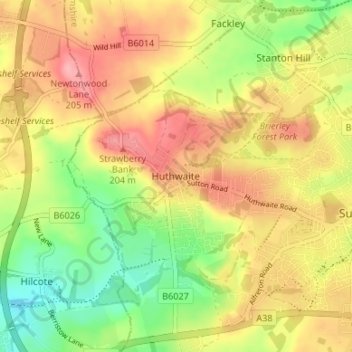
名称:Huthwaite地形图、海拔、地势。
地点:Huthwaite, Ashfield, Nottinghamshire, East Midlands, England, NG17 2LX, United Kingdom (53.10939 -1.32115 53.14939 -1.28115)
平均海拔:161 米
最低海拔:106 米
最高海拔:210 米
点击地图以查看其地形、其海拔和其地势。
United Kingdom > England > Nottinghamshire > Ashfield
平均海拔:145 米
平均海拔:118 米
United Kingdom > England > Nottinghamshire > Ashfield > Stanton Hill
平均海拔:154 米
United Kingdom > England > Nottinghamshire > Ashfield > Sutton-in-Ashfield
平均海拔:155 米