
06010地形图
点击地图以显示海拔。
关于这张地图
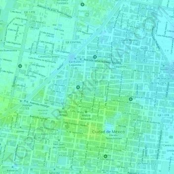
名称:06010地形图、海拔、地势。
地点:06010, Mexico City, Cuauhtémoc, Mexico City, Mexico (19.43946 -99.13672 19.43956 -99.13662)
平均海拔:2,234 米
最低海拔:2,229 米
最高海拔:2,239 米
其他地形图
点击地图以查看其地形、其海拔和其地势。
Xochimilco
Much of the borough's land is former lakebed. Its main elevations include Xochitepec and Tlacualleli mountains along with two volcanoes named Teutli and Tzompol. It contains two natural rivers called Santiago and Tepapantla along with the various canals, which is what is left of the lake. The elevated areas of…
平均海拔:2,241 米