
Gordonville地形图
点击地图以显示海拔。
关于这张地图
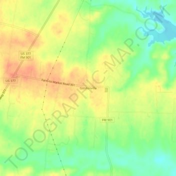
名称:Gordonville地形图、海拔、地势。
地点:Gordonville, Grayson County, Texas, United States (33.77566 -96.87306 33.81566 -96.83306)
平均海拔:211 米
最低海拔:186 米
最高海拔:231 米
其他地形图
点击地图以查看其地形、其海拔和其地势。
Howe
United States > Texas > Grayson County
Howe's elevation of 860 feet (260 m) is the highest point along US 75 between the Red River and the Gulf of Mexico.
平均海拔:248 米