East Monroe地形图
点击地图以显示海拔。
关于这张地图
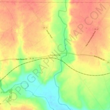
名称:East Monroe地形图、海拔、地势。
地点:East Monroe, Highland County, Ohio, 45135, United States (39.33867 -83.51881 39.37867 -83.47881)
平均海拔:297 米
最低海拔:257 米
最高海拔:322 米
其他地形图
点击地图以查看其地形、其海拔和其地势。

点击地图以显示海拔。
名称:East Monroe地形图、海拔、地势。
地点:East Monroe, Highland County, Ohio, 45135, United States (39.33867 -83.51881 39.37867 -83.47881)
平均海拔:297 米
最低海拔:257 米
最高海拔:322 米
点击地图以查看其地形、其海拔和其地势。