
Cross in Hand地形图
点击地图以显示海拔。
关于这张地图
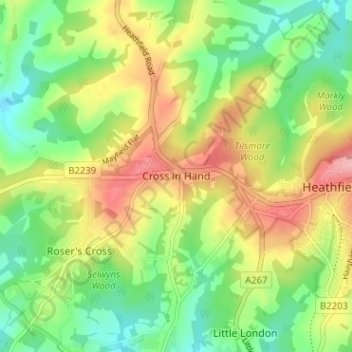
名称:Cross in Hand地形图、海拔、地势。
平均海拔:113 米
最低海拔:63 米
最高海拔:180 米
其他地形图
点击地图以查看其地形、其海拔和其地势。
Punnetts Town Recreation Ground
United Kingdom > England > East Sussex > Wealden > Punnett's Town > Chapel Cross
平均海拔:125 米
Crowborough
United Kingdom > England > East Sussex > Wealden
In the late 19th century, Crowborough was promoted as a health resort based on its high elevation, the rolling hills and surrounding forest. Estate Agents even called it "Scotland in Sussex". The town's golf course opened in 1895, followed by a fire station and hospital in 1900.
平均海拔:146 米
Ashdown Forest
United Kingdom > England > East Sussex > Wealden
Ashdown Forest is an ancient area of open heathland occupying the highest sandy ridge-top of the High Weald Area of Outstanding Natural Beauty. It is situated 30 miles (48 km) south of London in the county East Sussex, England. Rising to an elevation of 732 feet (223 m) above sea level, its heights provide…
平均海拔:117 米
Broadwater Warren Nature Reserve
United Kingdom > England > East Sussex > Wealden > Groombridge
平均海拔:84 米
Crowborough
United Kingdom > England > East Sussex > Wealden
In the late 19th century, Crowborough was promoted as a health resort based on its high elevation, the rolling hills and surrounding forest. Estate agents even called it "Scotland in Sussex". The town's golf course opened in 1895, followed by a fire station and hospital in 1900.
平均海拔:146 米