
Low Gap地形图
点击地图以显示海拔。
关于这张地图
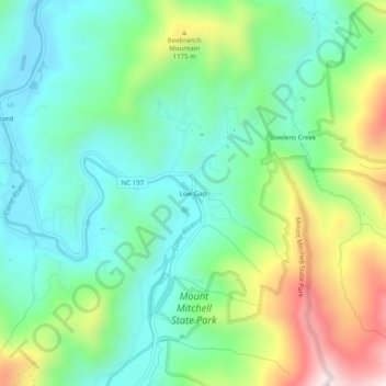
名称:Low Gap地形图、海拔、地势。
地点:Low Gap, Yancey County, North Carolina, 28714, United States (35.85206 -82.31790 35.89206 -82.27790)
平均海拔:994 米
最低海拔:806 米
最高海拔:1,410 米
其他地形图
点击地图以查看其地形、其海拔和其地势。
Mount Mitchell State Park
United States > North Carolina > Yancey County > Burnsville
In addition to Mount Mitchell itself, the park encompasses several other peaks which top out at over 6,000 feet (1,800 m) in elevation, including Mount Hallback, Mount Craig (just 52 feet (16 m) shy of Mount Mitchell in elevation and the second highest peak east of the Mississippi River), Big Tom and Balsam…
平均海拔:1,271 米