
Palo Cedro地形图
点击地图以显示海拔。
Palo Cedro
Palo Cedro is located at 40°33′4″N 122°14′3″W / 40.55111°N 122.23417°W / 40.55111; -122.23417 (40.551091, −122.234255) at an elevation of 465 ft (143 m) above sea level.
关于这张地图
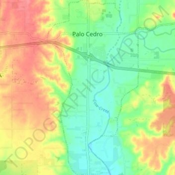
名称:Palo Cedro地形图、海拔、地势。
平均海拔:157 米
最低海拔:126 米
最高海拔:193 米
其他地形图
点击地图以查看其地形、其海拔和其地势。
Enterprise
United States > California > Shasta County > Redding
It lies at an elevation of 538 feet (164 m).
平均海拔:166 米
Lassen Peak
United States > California > Shasta County
Lassen Peak (/ˈlæsən/ LASS-ən), commonly referred to as Mount Lassen, is a 10,457 ft (3,187 m) lava dome volcano in Lassen Volcanic National Park in Northern California. Located in the Shasta Cascade region above the northern Sacramento Valley, it is the southernmost active volcano in the Cascade Range of…
平均海拔:2,689 米
Shasta
United States > California > Shasta County
Shasta is a census-designated place (CDP) in Shasta County, California, United States. Shasta sits at an elevation of 843 feet (257 m). Its population is 1,043 as of the 2020 census, down from 1,771 from the 2010 census.
平均海拔:351 米
Redding
United States > California > Shasta County > Redding
The elevation in Redding is 495 feet (151 meters) on average, whereas anywhere to the north, east, or west of downtown ranges between 550 feet (170 m) and 800 feet (240 m) feet. Southern portions range between 400 feet (120 m) and 500 feet (150 m).
平均海拔:312 米