点击地图以显示海拔。
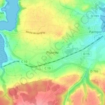
名称:Plounez地形图、海拔、地势。
地点:Plounez, Paimpol, Guingamp, Côtes-d'Armor, Brittany, Metropolitan France, 22500, France (48.75157 -3.09326 48.79157 -3.05326)
平均海拔:38 米
最低海拔:-1 米
最高海拔:87 米
点击地图以查看其地形、其海拔和其地势。
France > Brittany > Côtes-d'Armor
平均海拔:64 米
平均海拔:88 米
平均海拔:248 米
平均海拔:213 米
France > Brittany > Côtes-d'Armor > Jugon-les-Lacs > Le Goëland
平均海拔:60 米
平均海拔:43 米
平均海拔:73 米
平均海拔:197 米
平均海拔:81 米
平均海拔:125 米
平均海拔:50 米
平均海拔:158 米
平均海拔:131 米
平均海拔:270 米
平均海拔:59 米
平均海拔:52 米
平均海拔:42 米
平均海拔:227 米
France > Brittany > Côtes-d'Armor > Sévignac > La Villion
平均海拔:107 米
平均海拔:27 米
France > Brittany > Côtes-d'Armor > Plaintel
平均海拔:177 米
France > Brittany > Côtes-d'Armor > Plévenon
平均海拔:14 米
平均海拔:39 米
France > Brittany > Côtes-d'Armor > Binic-Étables-sur-Mer
平均海拔:37 米
平均海拔:71 米
平均海拔:149 米
平均海拔:32 米
平均海拔:35 米
France > Brittany > Côtes-d'Armor > Val-d'Arguenon
平均海拔:53 米
平均海拔:74 米
France > Brittany > Côtes-d'Armor > Le Mené
平均海拔:238 米
平均海拔:118 米
平均海拔:87 米
平均海拔:103 米
France > Brittany > Côtes-d'Armor > Jugon-les-Lacs
平均海拔:62 米
平均海拔:91 米
France > Brittany > Côtes-d'Armor > Pleumeur-Bodou > Run Losquet
平均海拔:4 米
France > Brittany > Côtes-d'Armor > Plouguenast-Langast
平均海拔:183 米
平均海拔:237 米
平均海拔:132 米
平均海拔:135 米
France > Brittany > Côtes-d'Armor > La Roche
平均海拔:51 米
平均海拔:182 米
平均海拔:57 米
平均海拔:34 米
平均海拔:140 米
平均海拔:22 米
France > Brittany > Côtes-d'Armor > Guerlédan
平均海拔:145 米
France > Brittany > Côtes-d'Armor > Trévé
平均海拔:160 米
France > Brittany > Côtes-d'Armor > Créhen
France > Brittany > Côtes-d'Armor > Gouarec
France > Brittany > Côtes-d'Armor > Guingamp
平均海拔:93 米
平均海拔:179 米
France > Brittany > Côtes-d'Armor > Plounévez-Quintin
平均海拔:196 米
平均海拔:84 米
平均海拔:21 米
平均海拔:10 米
平均海拔:77 米
平均海拔:41 米
平均海拔:245 米