
Talmadge地形图
点击地图以显示海拔。
关于这张地图
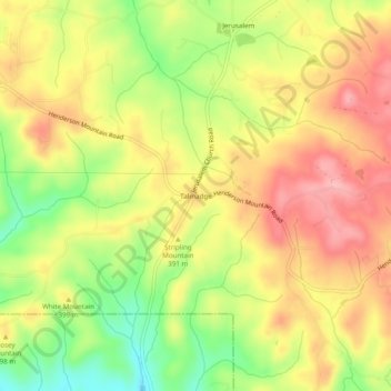
名称:Talmadge地形图、海拔、地势。
地点:Talmadge, Pickens County, Georgia, United States (34.40426 -84.60743 34.44426 -84.56743)
平均海拔:378 米
最低海拔:303 米
最高海拔:438 米
其他地形图
点击地图以查看其地形、其海拔和其地势。
Jasper
United States > Georgia > Pickens County
Jasper was founded in 1853 as seat of the newly formed Pickens County. It was incorporated in 1857 as a town and in 1957 as a city. The community is named for William Jasper, a hero of the American Revolutionary War. Jasper is situated at an elevation of 1,463 feet (446 m).
平均海拔:408 米