
Fulda地形图
点击地图以显示海拔。
关于这张地图
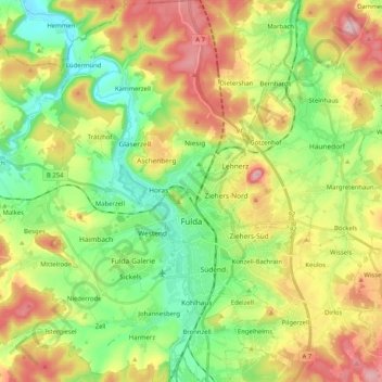
名称:Fulda地形图、海拔、地势。
地点:Fulda, Landkreis Fulda, Hesse, Germany (50.49954 9.56614 50.62941 9.73298)
平均海拔:324 米
最低海拔:225 米
最高海拔:470 米
其他地形图
点击地图以查看其地形、其海拔和其地势。
Milseburg
Germany > Hesse > Landkreis Fulda
The Milseburg is an extinct volcano and at 835 metres (2,740 ft) above sea level the second highest elevation in the Hessian part of the Rhön Mountains, Germany. The hill is located east of Fulda, near the villages of Kleinsassen and Danzwiesen. It is a popular destination for hikers and bikers.…
平均海拔:619 米