
Cabuyao地形图
点击地图以显示海拔。
关于这张地图
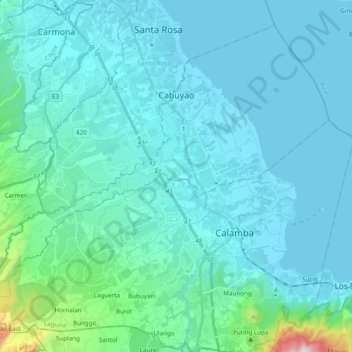
名称:Cabuyao地形图、海拔、地势。
地点:Cabuyao, Laguna, Calabarzon, 4025, Philippines (14.15570 121.01371 14.31678 121.20752)
平均海拔:79 米
最低海拔:0 米
最高海拔:804 米
其他地形图
点击地图以查看其地形、其海拔和其地势。
Mount Makiling
Philippines > Laguna > Los Baños
Mount Makiling (also spelled Maquiling) is an inactive stratovolcano located in the provinces of Laguna and Batangas on the island of Luzon in the Philippines. The mountain rises to an elevation of 1,090 meters (3,580 ft) above mean sea level and is the highest feature of the Laguna Volcanic Field. The volcano…
平均海拔:753 米
Mount San Cristobal
Philippines > Laguna > Rizal
Mount San Cristobal is a potentially active stratovolcano at the boundary of the provinces of Laguna and Quezon on the island of Luzon, Philippines. The mountain rises to an elevation of 1,470 m (4,820 ft) above mean sea level and is one of the volcanic features of Macolod Corridor.
平均海拔:1,021 米
Mount Makiling
Philippines > Laguna > Los Baños
Mount Makiling (also spelled Maquiling) is an inactive stratovolcano located in the provinces of Laguna and Batangas on the island of Luzon in the Philippines. The mountain rises to an elevation of 1,090 meters (3,580 ft) above mean sea level and is the highest feature of the Laguna Volcanic Field. The volcano…
平均海拔:753 米