
Stokes Field Pond地形图
点击地图以显示海拔。
关于这张地图
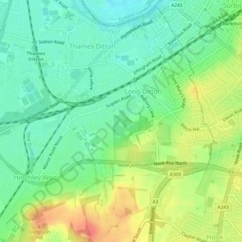
名称:Stokes Field Pond地形图、海拔、地势。
平均海拔:23 米
最低海拔:0 米
最高海拔:59 米
其他地形图
点击地图以查看其地形、其海拔和其地势。
Esher
United Kingdom > England > Surrey > Elmbridge
Esher is an outlying suburb of London, close to the London–Surrey border; with Esher Commons at its southern end, the town marks one limit of the Greater London Built-Up Area. Esher has a linear commercial high street and is otherwise suburban in density, with varying elevations, few high rise buildings and…
平均海拔:21 米
Cobham
United Kingdom > England > Surrey > Elmbridge
The River Mole runs through Cobham, with a visitor area and well-surfaced path by the mill in the High Street, dividing the low-rise urban village/town centre from the remaining agricultural parts of Cobham in the west and south. This can flood small, old parts of the village centre in extreme rainfall.…
平均海拔:28 米