
Shadowood地形图
点击地图以显示海拔。
关于这张地图
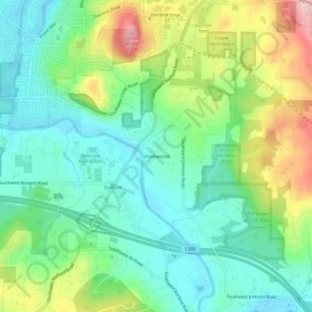
名称:Shadowood地形图、海拔、地势。
地点:Shadowood, Clackamas County, Oregon, 97034, United States (45.35873 -122.71454 45.39873 -122.67454)
平均海拔:95 米
最低海拔:30 米
最高海拔:230 米
其他地形图
点击地图以查看其地形、其海拔和其地势。
Sandy
United States > Oregon > Clackamas County
According to the United States Census Bureau, the city has a total area of 3.14 square miles (8.13 km2), consisting almost entirely of land. Its elevation is 967 feet (295 m).
平均海拔:247 米
Sandy
United States > Oregon > Clackamas County
According to the United States Census Bureau, the city has a total area of 3.14 square miles (8.13 km2), consisting almost entirely of land. Its elevation is 967 feet (295 m).
平均海拔:247 米
Wilsonville
United States > Oregon > Clackamas County
Wilsonville is located on the southern edge of the Portland metropolitan area sitting at an elevation of 154 feet (47 m) above sea level. Primarily in the southwestern part of Clackamas County, the northern section is in Washington County. It is located on the north side of the Willamette River around where…
平均海拔:60 米
Sandy
United States > Oregon > Clackamas County
According to the United States Census Bureau, the city has a total area of 3.14 square miles (8.13 km2), consisting almost entirely of land. Its elevation is 967 feet (295 m).
平均海拔:247 米