
Crockett地形图
点击地图以显示海拔。
关于这张地图
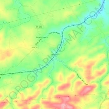
名称:Crockett地形图、海拔、地势。
地点:Crockett, Wythe County, Virginia, 24323, United States (36.86623 -81.21204 36.90623 -81.17204)
平均海拔:750 米
最低海拔:688 米
最高海拔:822 米
其他地形图
点击地图以查看其地形、其海拔和其地势。
Wytheville
United States > Virginia > Wythe County
Wytheville is nestled within the scenic Appalachian Mountains, characterized by a varied topography that features rolling hills, gentle valleys, and steep ridges. The town sits at an elevation of approximately 2,300 feet, which contributes to its cooler climate and offers picturesque views of the surrounding…
平均海拔:720 米
Wytheville
United States > Virginia > Wythe County
Due to its elevation, the climate of Wytheville is either classified as mountain temperate or humid subtropical (Köppen Cfb or Cfa, respectively), and the town straddles the border between USDA Plant Hardiness Zones 6B and 7A. Summers are warm and humid, although significantly cooler than low-elevation places…
平均海拔:720 米