
Dale地形图
点击地图以显示海拔。
关于这张地图
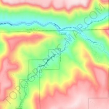
名称:Dale地形图、海拔、地势。
地点:Dale, Grant County, Oregon, United States (44.96845 -118.96841 45.00845 -118.92841)
平均海拔:1,035 米
最低海拔:834 米
最高海拔:1,214 米
其他地形图
点击地图以查看其地形、其海拔和其地势。
Canyon City
United States > Oregon > Grant County
The city is at an elevation of about 3,200 feet (980 m). Between Canyon City and Burns, to the south, Route 395 passes through parts of the Malheur National Forest. According to the United States Census Bureau, the town has a total area of 1.41 square miles (3.65 km2), all land.
平均海拔:1,078 米
Canyon City
United States > Oregon > Grant County > Canyon City
The city is at an elevation of about 3,200 feet (980 m). Between Canyon City and Burns, to the south, Route 395 passes through parts of the Malheur National Forest. According to the United States Census Bureau, the town has a total area of 1.41 square miles (3.65 km2), all land.
平均海拔:1,078 米