
Buffalo地形图
点击地图以显示海拔。
关于这张地图
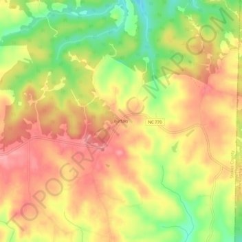
名称:Buffalo地形图、海拔、地势。
地点:Buffalo, Stokes County, North Carolina, United States (36.47514 -80.07282 36.51514 -80.03282)
平均海拔:303 米
最低海拔:245 米
最高海拔:343 米
其他地形图
点击地图以查看其地形、其海拔和其地势。
Hanging Rock State Park
United States > North Carolina > Stokes County > Danbury
Hanging Rock State Park is located in the Sauratown Mountain Range, one of the most easterly mountain ranges in the state. Often called "the mountains away from the mountains," the Sauratown range is made up of monadnocks that are separated from the nearby Blue Ridge Mountains. The Sauratown Mountains lie…
平均海拔:323 米