
Gateway地形图
点击地图以显示海拔。
关于这张地图
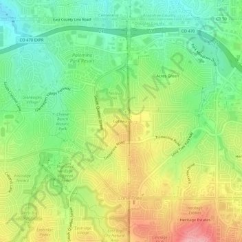
名称:Gateway地形图、海拔、地势。
地点:Gateway, Douglas County, Colorado, 80130, United States (39.52916 -104.92609 39.56916 -104.88609)
平均海拔:1,785 米
最低海拔:1,728 米
最高海拔:1,862 米
其他地形图
点击地图以查看其地形、其海拔和其地势。
Castle Rock
United States > Colorado > Douglas County
Castle Rock is located at 39°22′20″N 104°51′22″W / 39.37222°N 104.85611°W / 39.37222; -104.85611 (39.372212, −104.856090) at an elevation of 6,224 feet (1,897 m). Castle Rock is in central Colorado at the junction of Interstate 25 and State Highway 86, 28 mi (45 km) south of downtown…
平均海拔:1,952 米
Parker
United States > Colorado > Douglas County
Parker is located in northeastern Douglas County. Its northernmost border follows the Arapahoe County line, and the city of Aurora touches the town's northeast border. The center of Parker is 23 miles (37 km) southeast of downtown Denver. Castle Rock, the Douglas County seat, is 15 miles (24 km) to the…
平均海拔:1,845 米
Castle Pines
United States > Colorado > Douglas County
Castle Pines is located at 39°28′18″N 104°53′41″W / 39.471742°N 104.894827°W / 39.471742; -104.894827 (39.471742, -104.894827) at an elevation of 6,368 feet (1,941 m). Located on Interstate 25 in central Colorado, Castle Pines is 20 mi (32 km) south of downtown Denver and 43 mi (69 km)…
平均海拔:1,924 米
Castle Rock
United States > Colorado > Douglas County
Castle Rock is located at 39°22′20″N 104°51′22″W / 39.37222°N 104.85611°W / 39.37222; -104.85611 (39.372212, −104.856090) at an elevation of 6,224 feet (1,897 m). Castle Rock is in central Colorado at the junction of Interstate 25 and State Highway 86, 28 mi (45 km) south of downtown…
平均海拔:1,952 米