
Tire Junction地形图
点击地图以显示海拔。
关于这张地图
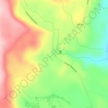
名称:Tire Junction地形图、海拔、地势。
地点:Tire Junction, Skamania County, Washington, United States (46.08808 -121.73144 46.10808 -121.71144)
平均海拔:1,099 米
最低海拔:972 米
最高海拔:1,231 米
其他地形图
点击地图以查看其地形、其海拔和其地势。
Gifford Pinchot National Forest
United States > Washington > Skamania County
Gifford Pinchot National Forest is located in a mountainous region approximately between Mount St. Helens to the west, Mount Adams to the east, Mount Rainier National Park to the north, and the Columbia River to the south. This region of Southwest Washington is noted for its complex topography and volcanic…
平均海拔:769 米
Spirit Lake
United States > Washington > Skamania County
Prior to 1980, Spirit Lake consisted of two arms that occupied what had been the valleys of the North Fork Toutle River and a tributary. About 4,000 years ago, these valleys were blocked by lahars and pyroclastic flow deposits from Mount St. Helens to form the pre-1980 Spirit Lake. The longest branch of Spirit…
平均海拔:1,144 米