
Cabarita Point地形图
点击地图以显示海拔。
关于这张地图
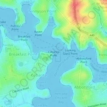
名称:Cabarita Point地形图、海拔、地势。
平均海拔:12 米
最低海拔:-2 米
最高海拔:54 米
其他地形图
点击地图以查看其地形、其海拔和其地势。
Wentworth Falls
Australia > New South Wales > Sydney
Wentworth Falls (postcode: 2782) is a town in the Blue Mountains region of New South Wales, situated approximately 100 kilometres (62 mi) west of the Sydney central business district, and about 8 kilometres (5.0 mi) east of Katoomba, Australia on the Great Western Highway, with a Wentworth Falls railway…
平均海拔:708 米
Davidson
Australia > New South Wales > Sydney
Davidson features uneven topography, in large part due to the area's origins as a mining quarry, as well as its proximity to Garigal National Park. Steep descents are evident in Stone Parade, Borgnis Street and Maitland Street, whereas more undulatory landscapes can be seen along parts of Prahran Avenue and…
平均海拔:98 米
Lucas Heights
Australia > New South Wales > Sydney
Due to its elevation, Lucas Heights is one of the few places in Sydney that has a borderline Oceanic (Cfb) and a Humid subtropical climate (Cfa).
平均海拔:115 米
Glebe
Australia > New South Wales > Sydney
The land was not suited to farming because of its topography and soils and the first European associated with it, the Reverend Richard Johnson famously described his land as "four hundred acres not worth four pence". Despite its limited use for agricultural purposes the timber was a valuable raw material and…
平均海拔:18 米
Nielsen Park
Australia > New South Wales > Sydney
As is common in all coastal and estuarine areas of the Sydney Region, the Park contains many rock outcrops, particularly along the foreshore headlands. These are given some added interest by the remnants of the effect of a basalt dyke that runs from Mount Trefle to Bottle and Glass Point resulting in the…
平均海拔:14 米