
Tower Grove地形图
点击地图以显示海拔。
关于这张地图
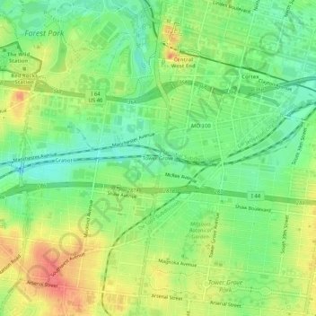
名称:Tower Grove地形图、海拔、地势。
地点:Tower Grove, St. Louis, Missouri, 63110, United States (38.60255 -90.28622 38.64255 -90.24622)
平均海拔:156 米
最低海拔:129 米
最高海拔:188 米
其他地形图
点击地图以查看其地形、其海拔和其地势。
Princeton Heights
United States > Missouri > St. Louis
Princeton Heights is an older South St. Louis residential neighborhood. The name "Princeton" came from the old deeds from the neighborhood named Princeton Place Subdivision or Addition. Its outer edge on the west is rather closely paralleled by the River des Peres drainage works, whose valley creates a general…
平均海拔:143 米