
Ohio地形图
点击地图以显示海拔。
关于这张地图
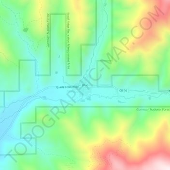
名称:Ohio地形图、海拔、地势。
地点:Ohio, Gunnison County, Colorado, 81237, United States (38.54859 -106.63130 38.58859 -106.59130)
平均海拔:2,771 米
最低海拔:2,565 米
最高海拔:3,175 米
其他地形图
点击地图以查看其地形、其海拔和其地势。
Crested Butte
United States > Colorado > Gunnison County
Crested Butte is located in north-central Gunnison County on the west side of the valley of the Slate River, along Coal Creek. Colorado State Highway 135 runs south from Crested Butte 27 miles (43 km) to Gunnison, the county seat. According to the United States Census Bureau, the town of Crested Butte has a…
平均海拔:2,798 米
Crested Butte
United States > Colorado > Gunnison County
At the 2020 United States Census, the town had a total area of 535 acres (2.166 km2), all of it land. Crested Butte lies at an elevation of 8,885 feet (2,708 m) above sea level.
平均海拔:2,798 米
Crested Butte
United States > Colorado > Gunnison County
At the 2020 United States census, the town had a total area of 535 acres (2.166 km2), all of it land. Crested Butte lies at an elevation of 8,885 feet (2,708 m) above sea level.
平均海拔:2,798 米