
Shenandoah Forest地形图
点击地图以显示海拔。
关于这张地图
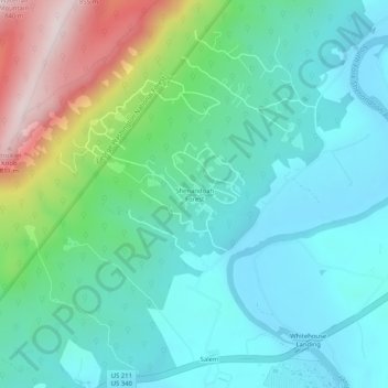
名称:Shenandoah Forest地形图、海拔、地势。
地点:Shenandoah Forest, Page County, Virginia, United States (38.64123 -78.56973 38.68123 -78.52973)
平均海拔:371 米
最低海拔:217 米
最高海拔:843 米
其他地形图
点击地图以查看其地形、其海拔和其地势。
Shenandoah National Park
United States > Virginia > Page County
Shenandoah National Park lies along the Blue Ridge Mountains in north-central Virginia. These mountains form a distinct highland rising to elevations above 4,000 feet (1,200 m). Local topographic relief between the Blue Ridge Mountains and Shenandoah Valley exceeds 3,000 feet (910 m) at some locations. The…
平均海拔:335 米
Shenandoah National Park
United States > Virginia > Page County
Shenandoah National Park lies along the Blue Ridge Mountains in north-central Virginia. These mountains form a distinct highland rising to elevations above 4,000 feet (1,200 m). Local topographic relief between the Blue Ridge Mountains and Shenandoah Valley exceeds 3,000 feet (900 m) at some locations. The…
平均海拔:335 米