
Mount Conner地形图
点击地图以显示海拔。
关于这张地图
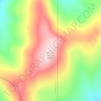
名称:Mount Conner地形图、海拔、地势。
地点:Mount Conner, Lincoln County, Montana, United States (48.32797 -114.85158 48.32807 -114.85148)
平均海拔:1,698 米
最低海拔:1,498 米
最高海拔:1,877 米
其他地形图
点击地图以查看其地形、其海拔和其地势。
Libby
United States > Montana > Lincoln County
According to the United States Census Bureau, the city has an area of 1.95 square miles (5.05 km2), of which 1.91 square miles (4.95 km2) is land and 0.04 square miles (0.10 km2) is water. Libby is in the Kootenai National Forest, between the Cabinet Mountains to the south and the Purcell Mountains to the…
平均海拔:676 米
Troy
United States > Montana > Lincoln County
Troy is a city in Lincoln County, Montana, United States. The population was 797 at the 2020 census. It lies at the lowest elevation of any settlement in Montana. The town is on U.S. Route 2, near Montana Highway 56, in the Kootenai River gorge by the Kootenai National Forest.
平均海拔:729 米
Libby
United States > Montana > Lincoln County
According to the United States Census Bureau, the city has an area of 1.95 square miles (5.05 km2), of which 1.91 square miles (4.95 km2) is land and 0.04 square miles (0.10 km2) is water. Libby is in the Kootenai National Forest, between the Cabinet Mountains to the south and the Purcell Mountains to the…
平均海拔:676 米