
Olivebridge地形图
点击地图以显示海拔。
关于这张地图
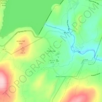
名称:Olivebridge地形图、海拔、地势。
平均海拔:189 米
最低海拔:105 米
最高海拔:322 米
其他地形图
点击地图以查看其地形、其海拔和其地势。
Catskills Visitor Center
United States > New York > Ulster County > Town of Shandaken > Beechford
平均海拔:301 米
Town of Denning
United States > New York > Ulster County
The town is in the Catskill Mountains and borders Sullivan County, New York. It is rugged and heavily wooded. Most settlement is concentrated around the hamlet of Sundown on Rondout Creek, along the two branches of the Neversink River or in the plateau between the two valleys northeast of Red Hill, at…
平均海拔:663 米
Catskills Visitor Center
United States > New York > Ulster County > Town of Shandaken > Beechford
平均海拔:301 米
Town of Denning
United States > New York > Ulster County
The town is in the Catskill Mountains and borders Sullivan County, New York. It is rugged and heavily wooded. Most settlement is concentrated around the hamlet of Sundown on Rondout Creek, along the two branches of the Neversink River or in the plateau between the two valleys northeast of Red Hill, at…
平均海拔:663 米