
Sabe地形图
点击地图以显示海拔。
关于这张地图
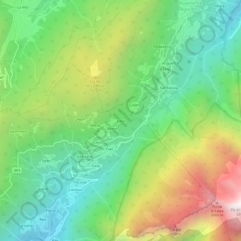
名称:Sabe地形图、海拔、地势。
地点:Sabe, Gosaldo, Belluno, Veneto, 32020, Italy (46.21283 11.98692 46.25283 12.02692)
平均海拔:1,199 米
最低海拔:605 米
最高海拔:2,232 米
其他地形图
点击地图以查看其地形、其海拔和其地势。
Gruppo del Pomagagnon
Italy > Veneto > Belluno > Cortina d'Ampezzo
Pomagagnon is a mountain of the Dolomites in Belluno, northern Italy. It has an elevation of 2,450 metres (8,038 ft) and is the southernmost mountain of the Cristallo Group, towering 1,200 metres (3,937 ft) over the resort of Cortina d'Ampezzo. The mountain is part of the "Natural Park of the Ampezzo…
平均海拔:1,758 米
Marmolada
The ridge is composed of several summits, decreasing in altitude from west to east: Punta Penia 3,343 metres (10,968 ft), Punta Rocca 3,309 metres (10,856 ft), Punta Ombretta 3,230 metres (10,600 ft), Monte Serauta 3,069 metres (10,069 ft), and Pizzo Serauta 3,035 metres (9,957 ft). An aerial tramway goes to…
平均海拔:1,896 米