
Cho Oyu地形图
点击地图以显示海拔。
Cho Oyu
Cho Oyu's height was originally measured at 26,750 feet (8,150 m) and at the time of the first ascent it was considered the 7th highest mountain on earth, after Dhaulagiri at 8,167 metres (26,795 ft) (Manaslu, now 8,156 metres (26,759 ft), was also estimated lower at 26,658 feet (8,125 m)). A 1984 estimate of 8,201 metres (26,906 ft) made it move up to sixth place. New measurements made in 1996 by the Government of Nepal Survey Department and the Finnish Meteorological Institute in preparation for the Nepal Topographic Maps put the height at 8,188 m, one remarkably similar to the 26,867 feet (8,189 m) used by Edmund Hillary in his 1955 book High Adventure.
关于这张地图
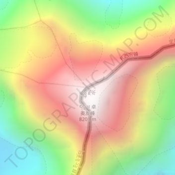
名称:Cho Oyu地形图、海拔、地势。
平均海拔:7,339 米
最低海拔:6,425 米
最高海拔:8,172 米
其他地形图
点击地图以查看其地形、其海拔和其地势。
Shelkar
China > Tibet > Tingri County
The town lies 7 kilometres (4.3 mi) off the Friendship Highway between Lhatse and Tingri, at an altitude of about 4,300 metres (14,100 ft), at the southern foot of 5,260 metres (17,260 ft) high Gyatso La. It is approximately 60 kilometres (37 mi) north-west of Mount Everest and just over 50 kilometres (31 mi)…
平均海拔:4,831 米