Shell地形图
点击地图以显示海拔。
关于这张地图
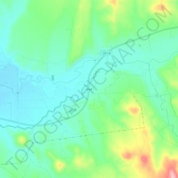
名称:Shell地形图、海拔、地势。
地点:Shell, Big Horn County, Wyoming, 82441, United States (44.51552 -107.79981 44.55552 -107.75981)
平均海拔:1,317 米
最低海拔:1,265 米
最高海拔:1,449 米
其他地形图
点击地图以查看其地形、其海拔和其地势。

点击地图以显示海拔。
名称:Shell地形图、海拔、地势。
地点:Shell, Big Horn County, Wyoming, 82441, United States (44.51552 -107.79981 44.55552 -107.75981)
平均海拔:1,317 米
最低海拔:1,265 米
最高海拔:1,449 米
点击地图以查看其地形、其海拔和其地势。