
Stonehill地形图
点击地图以显示海拔。
关于这张地图
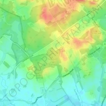
名称:Stonehill地形图、海拔、地势。
平均海拔:40 米
最低海拔:19 米
最高海拔:69 米
其他地形图
点击地图以查看其地形、其海拔和其地势。
Chobham
United Kingdom > England > Surrey > Surrey Heath
The rolling basin below reaches lowest elevations of between 30 metres (98 ft) in the centre of the west and 20 metres (66 ft) where the rivers join in the centre of the east. The rivers at the western point are less than 100 metres (330 ft) apart; to the east end of the parish where the parish adjoins the…
平均海拔:43 米