
Mwinilunga地形图
点击地图以显示海拔。
Mwinilunga
Mwinilunga sits in the extreme north-western corner of the country, close to the international borders with Angola and the Democratic Republic of the Congo. The geographical coordinates of Mwinilunga, Zambia are:11°43'02.0"S, 24°25'44.0"E (Latitude:-11.717222; Longitude:24.428889). The average elevation of the town is 1,391 metres (4,564 ft) above mean sea level.
关于这张地图
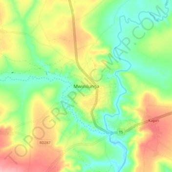
名称:Mwinilunga地形图、海拔、地势。
平均海拔:1,345 米
最低海拔:1,292 米
最高海拔:1,419 米
其他地形图
点击地图以查看其地形、其海拔和其地势。