
Bukit Gemuruh地形图
点击地图以显示海拔。
关于这张地图
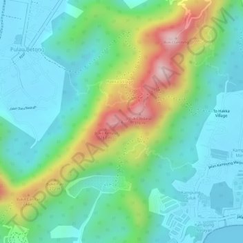
名称:Bukit Gemuruh地形图、海拔、地势。
地点:Bukit Gemuruh, George Town, Penang, 11920, Malaysia (5.29867 100.21383 5.29877 100.21393)
平均海拔:95 米
最低海拔:0 米
最高海拔:315 米
其他地形图
点击地图以查看其地形、其海拔和其地势。
Paya Terubong
Malaysia > Penang > George Town
The subdivision of Paya Terubong covers an area of 32.7 km2 (12.6 sq mi), forming a corridor that stretches from the central valleys of Penang Island to Jerejak Island off the eastern coast. It encompasses a varied topography and includes several neighbourhoods, namely Farlim, Bukit Jambul, Sungai Dua, Batu…
平均海拔:129 米
Penang Hill
Malaysia > Penang > George Town > Ayer Itam
A number of hills are covered by Penang Hill, with the highest point being Western Hill that stands at an altitude of 833 meters (2,733 feet) above sea level. Penang Hill is a hilly and forested area that stands out from the lowlands of Malaysia by being hilly and wooded. The area was used as a retreat during…
平均海拔:436 米
Penang National Park
Malaysia > Penang > George Town
There are two major trails in the Park, leading to Muka Head lighthouse and Pantai Kerachut respectively. The trail branches of at Pasir Pandak Hut. The trail leading to Muka Head lighthouse stops at Teluk Tukun, where it branches off to the canopy walkway, where it then links to Pantai Kerachut or vice versa.…
平均海拔:86 米