
Ash Springs地形图
点击地图以显示海拔。
关于这张地图
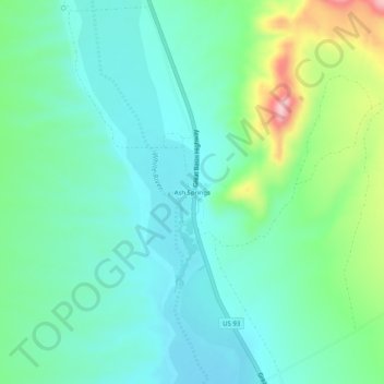
名称:Ash Springs地形图、海拔、地势。
地点:Ash Springs, Lincoln County, Nevada, United States (37.44305 -115.21421 37.48305 -115.17421)
平均海拔:1,142 米
最低海拔:1,086 米
最高海拔:1,311 米
其他地形图
点击地图以查看其地形、其海拔和其地势。
Caliente
United States > Nevada > Lincoln County
Caliente has a high-desert climate typical for a location around 4,000 feet (1,200 m) in elevation. Winters are chilly, but only moderately cold. Summers are characterized by blazing sunshine, long days, cool nights, and high diurnal temperature range. January highs average in the mid 40s, while July averages…
平均海拔:1,446 米
Caliente
United States > Nevada > Lincoln County
Caliente /kæliˈɛni/, /kæliˈɛnti/, formerly known as Culverwell and Calientes, is a city in Lincoln County, Nevada, United States. Its elevation is 4,300 feet (1,300 m). The population was 1,130 at the 2010 census, making it the least populated incorporated city in Nevada. The city's name originated from…
平均海拔:1,439 米