Roreto地形图
点击地图以显示海拔。
关于这张地图
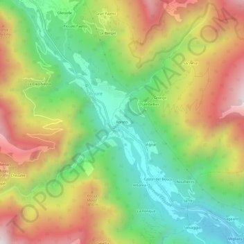
名称:Roreto地形图、海拔、地势。
地点:Roreto, Roure, Torino, Piemonte, Italia (44.97673 7.11550 45.01673 7.15550)
平均海拔:1,186 米
最低海拔:707 米
最高海拔:1,809 米
其他地形图
点击地图以查看其地形、其海拔和其地势。

点击地图以显示海拔。
名称:Roreto地形图、海拔、地势。
地点:Roreto, Roure, Torino, Piemonte, Italia (44.97673 7.11550 45.01673 7.15550)
平均海拔:1,186 米
最低海拔:707 米
最高海拔:1,809 米
点击地图以查看其地形、其海拔和其地势。