
Irgalem地形图
点击地图以显示海拔。
关于这张地图
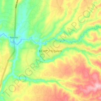
名称:Irgalem地形图、海拔、地势。
地点:Irgalem, Sidama, Ethiopia (6.70694 38.36576 6.78694 38.44576)
平均海拔:1,758 米
最低海拔:1,664 米
最高海拔:1,865 米
其他地形图
点击地图以查看其地形、其海拔和其地势。
Lake Hawassa
Lake Hawassa or Awasa, is an endorheic basin in Sidama Region of Ethiopia, located in the Main Ethiopian Rift south of Addis Ababa, the capital city of the country. According to the Statistical Abstract of Ethiopia for 1967/68, the lake is 16 km long and 9 km wide, with a surface area of 129 square kilometers.…
平均海拔:1,705 米