
Hager Mountain地形图
点击地图以显示海拔。
Hager Mountain
Hager Mountain is located on the edge of Oregon's high desert in the northwest corner of the Basin and Range Province of the western United States. The mountain is in Lake County, approximately 10 miles (16 km) south of the small unincorporated community of Silver Lake. The summit of Hager Mountain is at 7,189 feet (2,191 m). The mountain's topographic prominence is 1,455 feet (443 m).
关于这张地图
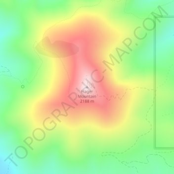
名称:Hager Mountain地形图、海拔、地势。
地点:Hager Mountain, Lake County, Oregon, United States (43.00937 -121.03168 43.00947 -121.03158)
平均海拔:1,882 米
最低海拔:1,640 米
最高海拔:2,183 米
其他地形图
点击地图以查看其地形、其海拔和其地势。
Valley Falls
United States > Oregon > Lake County
In 1832, John Work led his Hudson's Bay Company trapping brigade through the Valley Falls area. Work recorded the visit in his journal. In 1843, Captain John C. Fremont explored the area around Valley Falls. Fremont name Abert Rim and nearby Abert Lake after the head of the United States Army's topographical…
平均海拔:1,324 米
Lakeview
United States > Oregon > Lake County
Lakeview is a city in Lake County, Oregon, United States. The population was 2,418 at the 2020 census. It is the county seat of Lake County. The city bills itself as the "Tallest Town in Oregon" because of its elevation, 4,757 feet (1,450 m) above sea level. Lakeview is situated in the Goose Lake Valley at the…
平均海拔:1,562 米
Summer Lake
United States > Oregon > Lake County
Summer Lake was spotted and named by Captain John C. Frémont during his 1843 mapping expedition through central Oregon. Fremont and his Army topographical team were mapping the Oregon Territory from The Dalles on Columbia River to Sutter's Fort in Sacramento, California. On 16 December 1843, the expedition…
平均海拔:1,409 米
Paisley
United States > Oregon > Lake County
Paisley is located at an elevation of 4,374 feet (1,333 m). According to the United States Census Bureau, the city has a total area of 0.44 square miles (1.14 km2), all of it land. The Chewaucan River flows through the city.
平均海拔:1,355 米