
Mount Arvon地形图
点击地图以显示海拔。
Mount Arvon
Mount Arvon (/ɑːrvɒn/ ARR-vahn) at 1,979 feet (603 m), is the highest natural point in the U.S. state of Michigan. Located in L'Anse Township, Baraga County, Mount Arvon is part of the Huron Mountains. It rises about eight miles (13 km) south of Lake Superior (elevation 591 feet [180 m]). On the list of highest natural points in each U.S. state, Mount Arvon ranks 38th. It is the highest natural point in the East North Central states.
关于这张地图
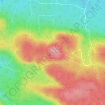
名称:Mount Arvon地形图、海拔、地势。
平均海拔:526 米
最低海拔:455 米
最高海拔:600 米