
San Narciso地形图
点击地图以显示海拔。
San Narciso
San Narciso is located in a relatively flat plain. West of the town is the South China Sea and to the east is bordered by the Sto. Tomas river are the Zambales Mountain Ranges. Average elevation is 3.6 metres (12 ft) above sea level and the highest elevation is 800 metres (2,600 ft) above sea level.
关于这张地图
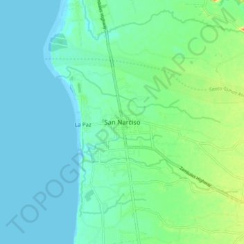
名称:San Narciso地形图、海拔、地势。
地点:San Narciso, Zambales, Central Luzon, 2205, Philippines (14.97552 120.03937 15.05552 120.11937)
平均海拔:11 米
最低海拔:0 米
最高海拔:43 米
其他地形图
点击地图以查看其地形、其海拔和其地势。