
Davis Islands地形图
点击地图以显示海拔。
关于这张地图
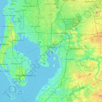
名称:Davis Islands地形图、海拔、地势。
平均海拔:14 米
最低海拔:-2 米
最高海拔:79 米
其他地形图
点击地图以查看其地形、其海拔和其地势。
Lutz
United States > Florida > Hillsborough County > Tampa
Lutz is characterized by a gently rolling topography that showcases the distinctive features of the central Florida landscape. The area has an average elevation of about 70 feet (21 meters) above sea level, contributing to its mild undulations rather than dramatic elevation changes. The terrain is marked by a…
平均海拔:20 米
Carrollwood
United States > Florida > Hillsborough County > Tampa
Carrollwood is located at 28.1 degrees north, 82.5 degrees west (28.0523, -82.4858). The elevation for the community is 39 feet (12 m) above sea level.
平均海拔:16 米
Carrollwood
United States > Florida > Hillsborough County > Tampa
Carrollwood is located at 28.1 degrees north, 82.5 degrees west (28.0523, -82.4858). The elevation for the community is 39 feet (12 m) above sea level.
平均海拔:16 米