
Onekaka地形图
点击地图以显示海拔。
关于这张地图
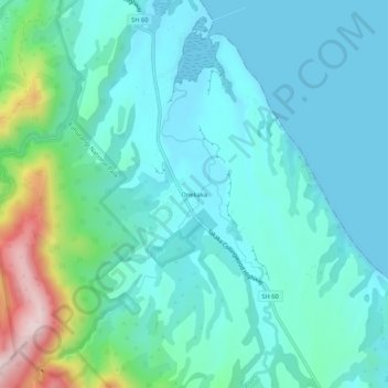
名称:Onekaka地形图、海拔、地势。
地点:Onekaka, Tasman, 7182, New Zealand (-40.78413 172.68827 -40.74413 172.72827)
平均海拔:73 米
最低海拔:0 米
最高海拔:385 米
其他地形图
点击地图以查看其地形、其海拔和其地势。
Spenser Mountains
New Zealand > Tasman > Hurunui District
The Spenser Mountains is a topographic landform in the northern South Island of New Zealand. Located at the southern end of the Nelson Lakes National Park and north of the Lewis Pass they form a natural border between the Canterbury and Tasman regions. Several peaks are named after characters in Edmund…
平均海拔:1,310 米