Oundle地形图
点击地图以显示海拔。
关于这张地图
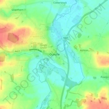
名称:Oundle地形图、海拔、地势。
地点:Oundle, North Northamptonshire, England, United Kingdom (52.46712 -0.52758 52.49437 -0.44484)
平均海拔:37 米
最低海拔:17 米
最高海拔:74 米
其他地形图
点击地图以查看其地形、其海拔和其地势。

点击地图以显示海拔。
名称:Oundle地形图、海拔、地势。
地点:Oundle, North Northamptonshire, England, United Kingdom (52.46712 -0.52758 52.49437 -0.44484)
平均海拔:37 米
最低海拔:17 米
最高海拔:74 米
点击地图以查看其地形、其海拔和其地势。