
Eagle Peak地形图
点击地图以显示海拔。
关于这张地图
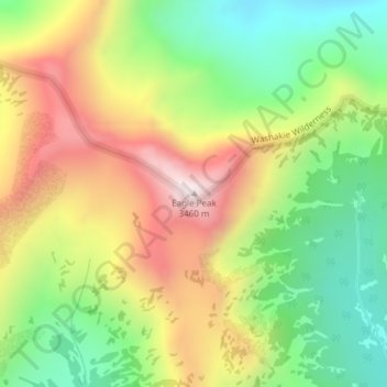
名称:Eagle Peak地形图、海拔、地势。
地点:Eagle Peak, Park County, Wyoming, United States (44.32013 -110.02696 44.32023 -110.02686)
平均海拔:2,963 米
最低海拔:2,571 米
最高海拔:3,447 米
其他地形图
点击地图以查看其地形、其海拔和其地势。
Cody
United States > Wyoming > Park County
Cody's elevation is approximately 5016 ft (1,500 m) above sea level. The main part of the city is split across three levels, separated by about 60 feet (18 m).
平均海拔:1,557 米
Cody
United States > Wyoming > Park County
Cody's elevation is approximately 5016 ft (1,500 m) above sea level. The main part of the city is split across three levels, separated by about 60 feet (18 m).
平均海拔:1,557 米
Cody
United States > Wyoming > Park County
Cody's elevation is approximately 4,997 feet (1,523 m) above sea level. The main part of the city is split across three levels, separated by about 60 feet (18 m).
平均海拔:1,557 米