
Madonnaville地形图
点击地图以显示海拔。
关于这张地图
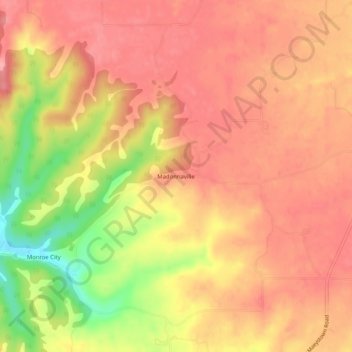
名称:Madonnaville地形图、海拔、地势。
地点:Madonnaville, Monroe County, Illinois, 62256, United States (38.24505 -90.26678 38.28505 -90.22678)
平均海拔:207 米
最低海拔:133 米
最高海拔:241 米
其他地形图
点击地图以查看其地形、其海拔和其地势。
Waterloo
United States > Illinois > Monroe County
Waterloo's history dates back to the 18th century, with the French being the first Europeans to settle in the area. The site was ideal because of its elevation; the proximity of the Mississippi River Valley brought frequent flooding to the lowlands. It was also close to Fort de Chartres, a French stronghold.…
平均海拔:186 米