
Banton地形图
点击地图以显示海拔。
Banton
The name "Banton" was derived from the Asi word batoon, meaning "rocky", referring to the mountainous and rocky topography of the island due to its volcanic origin. Another possible origin is the word bantoy, which is the Asi word for the venomous stonefish.
关于这张地图
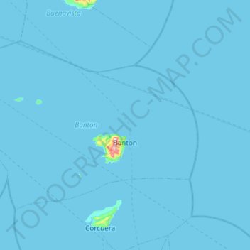
名称:Banton地形图、海拔、地势。
地点:Banton, Romblon, Mimaropa, 5515, Philippines (12.81883 121.75104 13.13917 122.23787)
平均海拔:3 米
最低海拔:0 米
最高海拔:592 米
其他地形图
点击地图以查看其地形、其海拔和其地势。
Mount Guiting-Guiting
Philippines > Romblon > Cajidiocan
Mount Guiting-Guiting or G2 is the highest mountain in the province of Romblon, located in Sibuyan Island, in the Philippines, with an elevation of 6,752 ft (2,058 m) above sea level. Its steep slopes and jagged peak, have earned it the reputation, as one of the most difficult and technically most challenging…
平均海拔:1,478 米