点击地图以显示海拔。
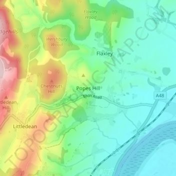
名称:Popes Hill地形图、海拔、地势。
地点:Popes Hill, Forest of Dean, Gloucestershire, England, GL14 1JT, United Kingdom (51.80663 -2.47540 51.84663 -2.43540)
平均海拔:81 米
最低海拔:0 米
最高海拔:267 米
点击地图以查看其地形、其海拔和其地势。
United Kingdom > England > Gloucestershire > Forest of Dean > Aylburton
平均海拔:37 米
United Kingdom > England > Gloucestershire > Forest of Dean
平均海拔:62 米
United Kingdom > England > Gloucestershire > Forest of Dean > Coleford
平均海拔:193 米
United Kingdom > England > Gloucestershire > Forest of Dean > Littledean
平均海拔:173 米
平均海拔:32 米
平均海拔:145 米
United Kingdom > England > Gloucestershire > Forest of Dean > May Hill
平均海拔:157 米
平均海拔:46 米
平均海拔:137 米
平均海拔:25 米
平均海拔:43 米
平均海拔:78 米
United Kingdom > England > Gloucestershire > Forest of Dean > Newland
平均海拔:151 米
平均海拔:178 米
平均海拔:26 米
平均海拔:210 米
平均海拔:50 米
平均海拔:148 米
平均海拔:130 米
平均海拔:77 米
平均海拔:49 米
平均海拔:54 米
平均海拔:147 米
平均海拔:175 米
United Kingdom > England > Gloucestershire > Forest of Dean > Mitcheldean
United Kingdom > England > Gloucestershire > Forest of Dean > Lydney > Naas
平均海拔:7 米