
West Devon地形图
点击地图以显示海拔。
关于这张地图
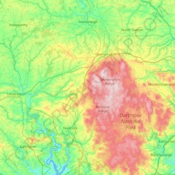
名称:West Devon地形图、海拔、地势。
地点:West Devon, Devon, Devon and Torbay, England, United Kingdom (50.42937 -4.33510 50.87462 -3.73227)
平均海拔:200 米
最低海拔:-2 米
最高海拔:612 米
其他地形图
点击地图以查看其地形、其海拔和其地势。
Plymouth
United Kingdom > England > Devon > Plymouth
The River Plym, which flows off Dartmoor to the north-east, forms a smaller estuary to the east of the city called Cattewater. Plymouth Sound is protected from the sea by the Plymouth Breakwater, in use since 1814. In the Sound is Drake's Island which is seen from Plymouth Hoe, a flat public area on top of…
平均海拔:81 米
Wistman's Wood (Nature Reserve)
United Kingdom > England > Devon > West Devon
Wistman's Wood is one of Britain's last remaining ancient temperate rainforests and one of three remote high-altitude oakwoods on Dartmoor in Devon, England. The first written document to mention Wistman's Wood dates to the 17th century, while more recent tree-ring studies show that individual trees could be…
平均海拔:433 米
Princetown
United Kingdom > England > Devon > West Devon
Princetown, like the rest of Dartmoor, experiences colder and wetter weather than most of Devon, especially because of its high altitude. Snow is uncommon but is usually heavy when it does fall. According to the Köppen climate classification the climate would be classified as Cfb bordering on Cfc.
平均海拔:406 米