
Ruang地形图
点击地图以显示海拔。
Ruang
Ruang is the southernmost stratovolcano in the Sangihe Islands arc, North Sulawesi, Indonesia. It comprises an island 4 by 5 kilometres (2.5 mi × 3.1 mi) wide. The summit contains a partial lava dome and reaches some 725 metres (2,379 ft) in altitude. From its summit, Klabat's peak in the south, that of Siau to the north, and Ternate to the east can all be seen.
关于这张地图
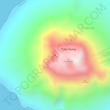
名称:Ruang地形图、海拔、地势。
平均海拔:274 米
最低海拔:0 米
最高海拔:724 米